Article Summary
A winter storm watch remains in place for Central Massachusetts, as a mix of rain and snow is expected for Sunday and Monday. The National Weather Service expects between 4 to 8 inches of snow to accumulate during this time. The storm could cause power outages and impact the Monday morning commute, but a period of dry weather and seasonable temperatures is forecasted to begin Tuesday.
Winter Storm Watch in Effect for Central Massachusetts with Lower Snow Accumulation Expected
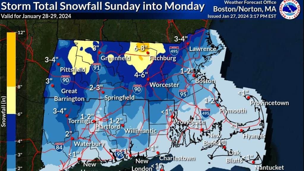
The National Weather Service maintains a winter storm watch for Worcester County, Central Massachusetts, though snowfall estimates for Sunday and Monday have been lowered.
The winter storm watch extends from 6 a.m. Sunday to 7 p.m. Monday. The weather forecast for Central Massachusetts now predicts a blend of rain and snow, with the possibility of up to 8 inches in the higher regions of northern Worcester County. This is a decrease from earlier forecasts which predicted up to a foot of snow.
Worcester city anticipates receiving 4 to 6 inches of snow, while the southern parts will likely experience lighter snowfall. Sunday’s high is expected to be in the mid 30s, with temperatures predicted to plummet below freezing overnight and wind gusts potentially reaching 35 mph.
Possible Difficult Commute and Power Failures on Monday
Due to a mixture of heavy, wet snow and icy glaze, commuters could face challenging conditions on Monday morning. The weather service also warns of potential power outages.
Already, this latest storm has contributed to a significantly wet month for the Worcester area. As of Thursday, Worcester city had measured 6.59 inches of total precipitation (consisting of both snow and rain), which is nearly 4 inches above the average, according to the National Weather Service.
Looking ahead, the forecast predicts a stretch of dry weather and seasonal temperatures starting Tuesday and lasting through the end of the week.
Read More US News
This article may have been created with the assistance of AI.

