Article Summary –
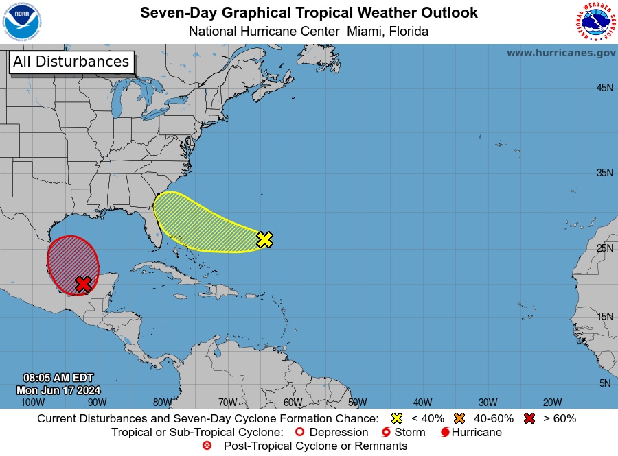
Hurricane season has started and two tropical disturbances are forming in the Atlantic that could impact the United States. The stronger disturbance is likely to become a tropical depression or storm and make a landfall in Mexico, however, moist flow on the northern side of its circulation could bring excessive rainfall to Texas, potentially leading to flash flooding. The other disturbance could develop into a low-end storm between northern Florida and the Carolinas, bringing squally weather with gusty winds and downpours.
Hurricane Season Developments
This year’s hurricane season has begun with two tropical disturbances in the Atlantic that could potentially impact the United States. Although neither are expected to escalate into a hurricane, both may cause tropical downpours and localized flooding.
Potential Disturbances in the Southwestern Gulf of Mexico & Texas
The stronger of the two disturbances, with a 70% likelihood of development according to the National Hurricane Center, is situated in the southwestern Gulf of Mexico. Predictions suggest it may become a tropical depression or storm, causing substantial rainfall in Texas, including Houston, with possible double-digit totals in certain areas. A Level 3 out of 4 risk area for flash flooding and excessive rainfall has been declared for large parts of the Texas coast.
Other Disturbances in the Northwestern Bahamas, Florida & Carolinas
An additional disturbance over the northwestern Bahamas could become a tropical depression or low-level storm, impacting northern Florida and the Carolinas later this week. It’s still uncertain where it might land. Experts forecast a potentially hyperactive hurricane season this year, owing to above-average water temperatures and a growing La Niña.
System 1 in Gulf of Mexico
Current satellite imagery shows a broad counter-clockwise swirl over the southwestern Gulf of Mexico, the Caribbean, and the Yucatán Peninsula. This large-scale low-pressure system could see a short-lived tropical storm dubbed Alberto if a concentrated lobe of spin consolidates and moves towards Mexico.
System 2 — Atlantic Ocean, Bahamas, Florida and Southeast
A broad pocket of spin exists over the northwestern Bahamas, which could result in the formation of a tropical depression. Weather models are inconsistent in predicting its pathway and potential impact. As such, it’s impossible to sort out any potential impacts or ascertain the timing of any hazards. For now, the National Hurricane Center estimates a 30 percent chance of eventual tropical development.
Read More US News
This article may have been created with the assistance of AI.

