California is home to some of the most incredible natural wonders in the world, from mountains and waterfalls to the world’s oldest tree.
California is famous for its beauty, and it’s easy to see why. With 840 miles of coastline, nine national parks, and hundreds of mountain ranges running through the state, California is not lacking in natural wonders.
It can be hard to find sites that are totally natural—from lakes that have been created by dams, to flower fields that are pruned by human hands. But thankfully, there are some places in California that are still extremely cool natural wonders.
From sand dunes that actually sing, to the driest place in the country, to some pretty unusual colored sand, these are some of the coolest natural wonders that can be found all across California.
1. Inspiration Point
Address: 1901 Spinnaker Drive, Ventura
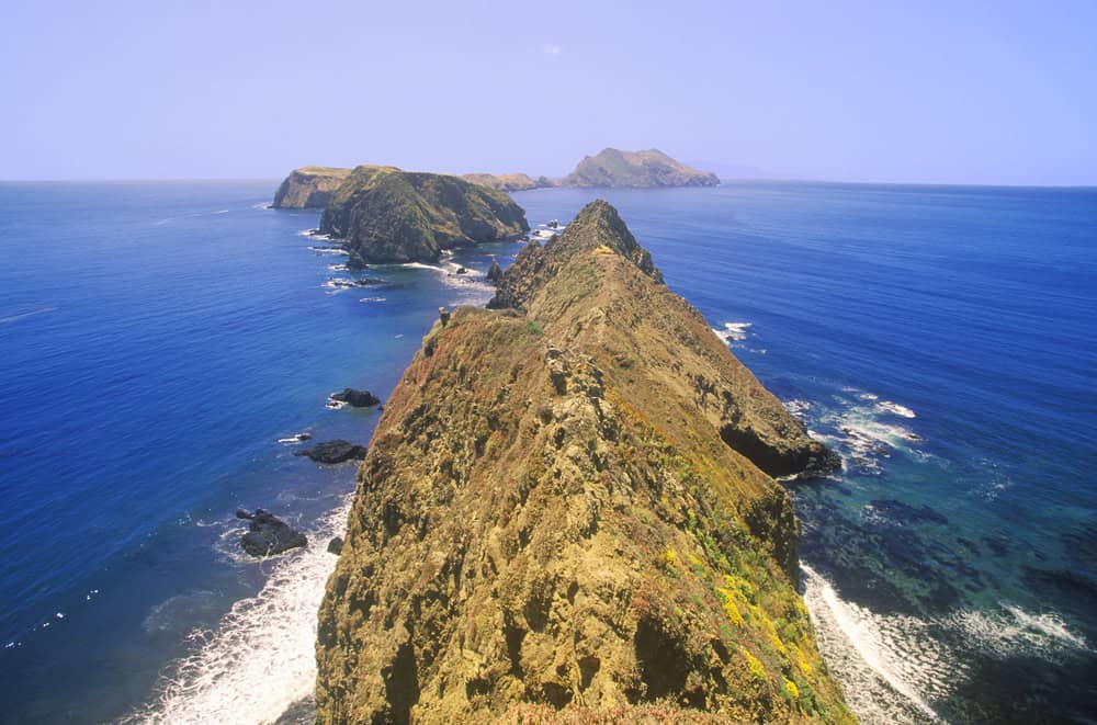
If the sight of islands, mountains, and endless ocean doesn’t provide visitors to Inspiration Point with a bit of inspiration, what will? The point is located on Anacapa Island, which is part of Channel Islands National Park, comprising five islands off the Southern California coast. Anacapa Island, the smallest of the northern Channel Islands, offers a 1.5-mile hike that leads up to Inspiration Point, a tremendous viewpoint overlooking the island, wildflowers, and marine birds.
The park is only accessible through private boats or traveling on the park’s concessionaire boats, but it also offers visitor centers in Ventura and Santa Barbara.
2. Joshua Tree National Park
Address: 74485 National Park Drive, Twentynine Palms
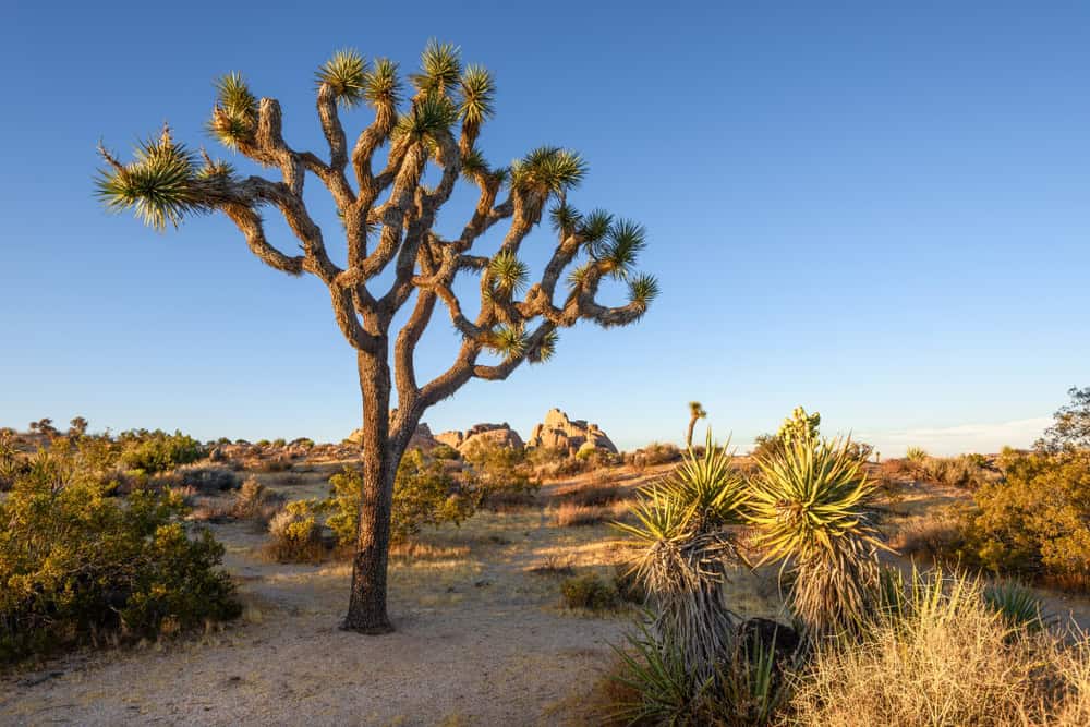
There are many beautiful hikes, scenic campgrounds, and exciting rock climbing opportunities in Joshua Tree National Park, but the main reason to go is right in the park’s name: to see yucca brevifolia, or as it’s better known, the Joshua tree. Named after Christian iconography, Joshua trees are primarily found in the Southwestern United States and northwest Mexico, and are known for their unusual, spiky branches.
Although the trees are a beloved natural wonder, they’re also endangered and face a risk of near extinction by the end of this century due to climate change. The plants, which can live for hundreds of years and are thought to be one of the oldest plants in California, depend on a specific climate to grow, and rising temperatures could reduce the Joshua tree’s ability to reproduce. This has led to calls to save the tree and resulted in California passing the Joshua Tree Protection Law in 2023, requiring the state to make a conservation plan for the plants.
3. Death Valley
Address P.O. Box 579, Death Valley
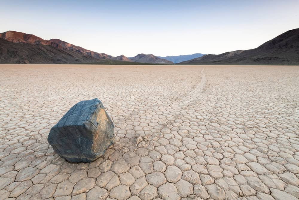
Known as the hottest, driest, and lowest place in the country, Death Valley is also one of the coolest natural wonders in all of California. The valley, which is located in Death Valley National Park, is notable for its extremes. Located near the California and Nevada border, Death Valley has been the site of the hottest temperature ever recorded on Earth, 134 degrees Fahrenheit in 1913, and its Badwater Basin is the lowest point in North America, at 282 feet below sea level.
Another cool feature of the valley is the sailing stones, a geological phenomenon that’s not found in too many other places, where rocks move on their own, and leave behind long tracks in the valley floor of Racetrack Playa, a dry lake, in Death Valley National Park. The stones move because rain fills the racetrack playa, creating a temporary pond, and nighttime freezing turns the pond into sheets of ice. When the ice melts in the morning, light winds can move the stones easily.
4. General Sherman Tree
Address: 47050 Generals Highway, Three Rivers
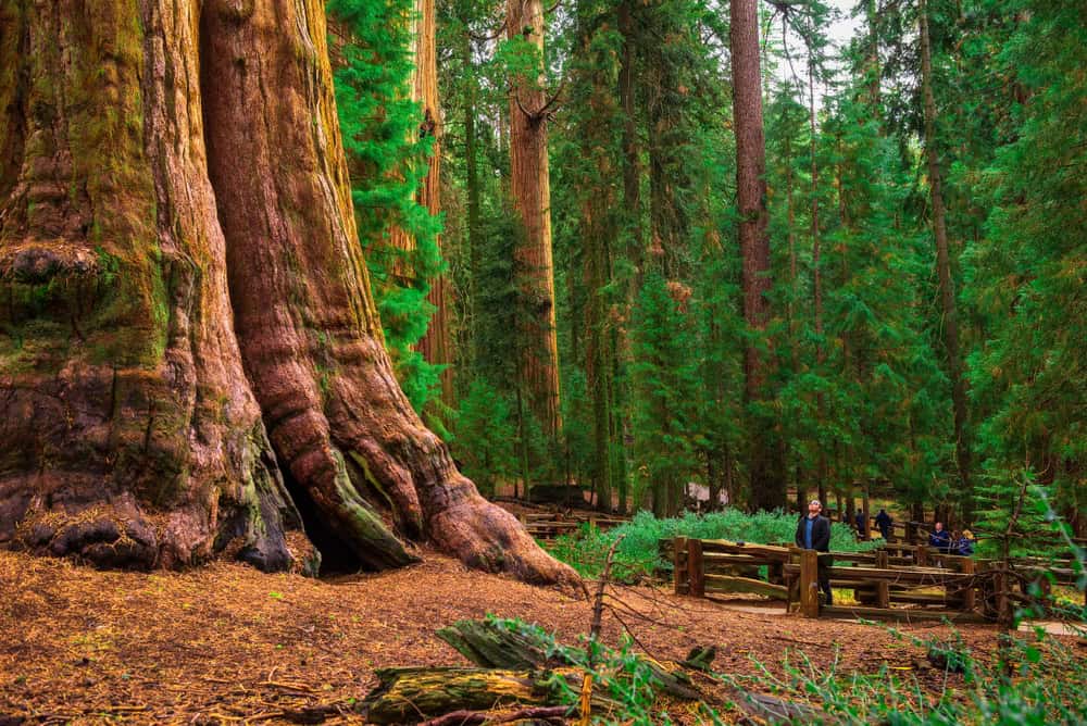
Is there anything more awe-inspiring and majestic than seeing a really massive tree? A tree that just astonishes visitors with how gigantic it is, making them marvel while thinking about how many rings must be inside the tree’s enormous trunk. There are a lot of trees that can do that in California, the home of the redwoods and massive sequoias, but none more so than the General Sherman Tree.
The General Sherman Tree is a giant sequoia, located in Sequoia National Park. Standing at 275 feet tall, the tree is estimated to have first been seeded between the years 700 B.C. and 300 B.C. While not the world’s tallest tree, it is both tall and has a large diameter, making it the world’s largest tree.
5. Yosemite Falls
Address: 9007 Village Drive, Yosemite National Park
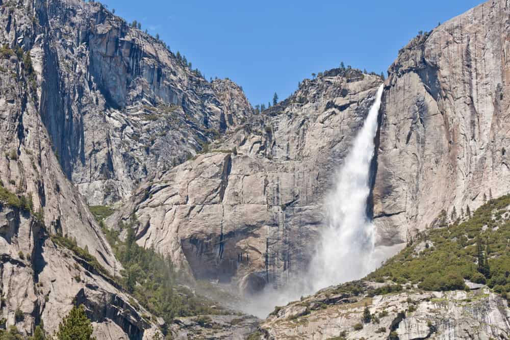
There are more than 1,000 named waterfalls in California, but among the most majestic is Yosemite Falls. Dropping more than 2,425 feet from its peak, Yosemite Falls is the tallest waterfall in the state, and among the tallest in the country. Located in Yosemite National Park, Yosemite Falls is one of the park’s most notable attractions.
One of the coolest parts of Yosemite Falls is its different sections. The waterfall is divided into three sections: the Upper Yosemite Fall, the Middle Cascades, and the Lower Yosemite Fall, making it all the more dramatic and scenic to view.
6. Petrified Forest
Address: 4100 Petrified Forest Road, Calistoga
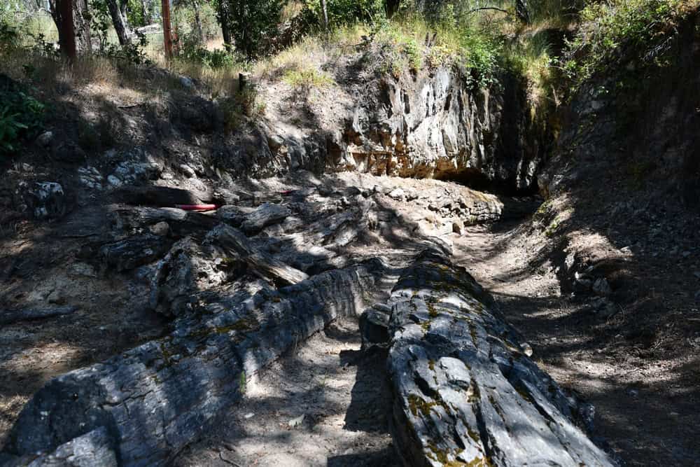
There are many old trees in California that date back hundreds or even thousands of years. But then there are trees that are far older, like those in the Petrified Forest in Calistoga. The Petrified Forest trees date back to the Pliocene Epoch, approximately 3.4 million years ago.
The trees are so ancient that they’re not even really trees anymore—now, they’re rocks, and fossils in a preserved ancient forest. After a volcanic explosion 3.4 million years ago, a forest of prehistoric redwood trees was knocked over and then covered in layers of volcanic ash, preserving the trees as fossils. They were discovered in 1870 by Swedish homesteader Charles Evans. Now, visitors can go see these fossilized trees and marvel at being in the presence of something that has been around for millions of years. The forest is open to visitors every day from 10 a.m. until 5 p.m.
7. Half Dome
Address: 9007 Village Drive, Yosemite National Park
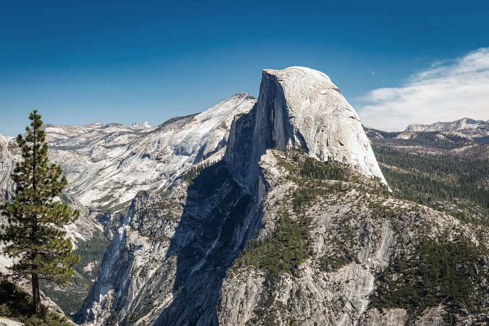
One of the most well-known features of Yosemite National Park is Half Dome, a massive batholith, or large mass of igneous rock, that rises more than 8,000 feet above sea level. Named for its distinctive shape, Half Dome used to be thought of as completely inaccessible, until it was first summited in 1875 by George Anderson. Now, it’s a popular, but strenuous, hiking spot.
It’s an intense process to hike Half Dome, even before entering the park. All interested hikers must first obtain a permit, which can be done online. It usually takes visitors between 10 and 12 hours to hike Half Dome. The hike gains approximately 5,000 feet in elevation from the valley floor to the top of Half Dome, making it an extreme accomplishment for anyone who reaches the summit. Otherwise, visitors to the park can enjoy views of the stunning batholith from the valley floor.
8. Pfeiffer Beach
Address: 9101 Sycamore Canyon Road, Big Sur
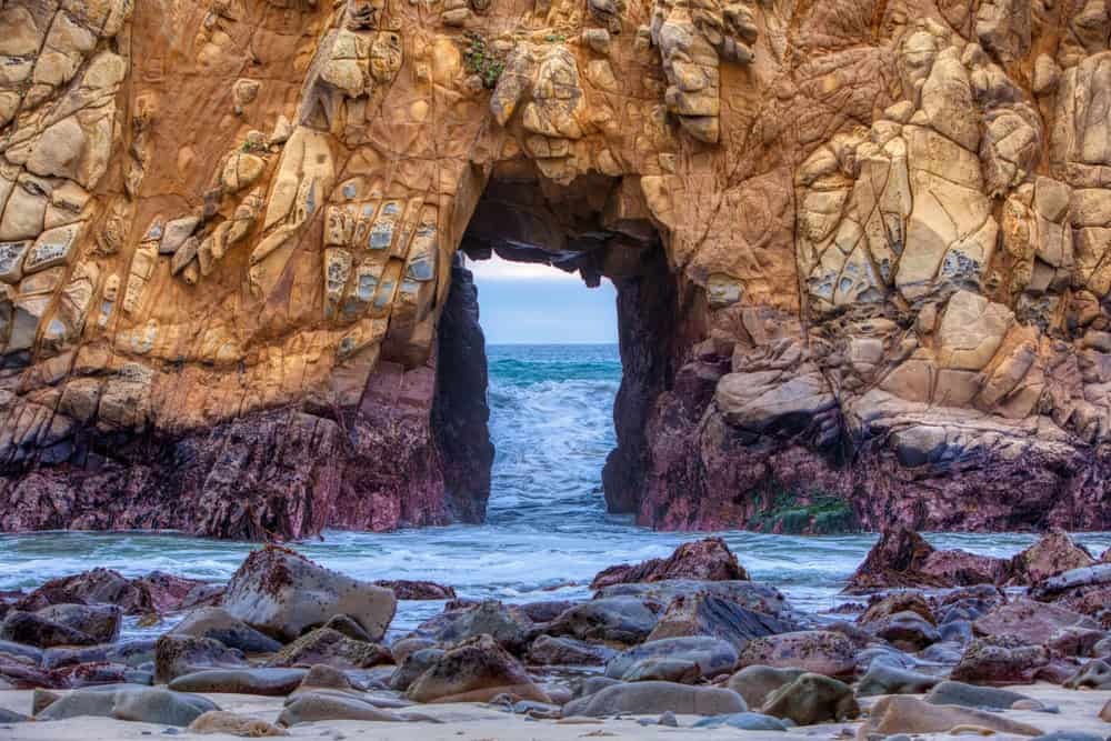
Arguably, all of California’s coastal beaches are impressive, scenic, and cool natural wonders, but one stands out above the rest: Pfeiffer Beach in Big Sur. While most beaches have tan or beige sand, Pfeiffer Beach has purple sand, caused by manganese garnet deposits that have washed down from the surrounding cliffs.
If purple sand wasn’t enough, Pfeiffer Beach is also well-known for its scenic keyhole rock. The beach is part of the Los Padres National Forest, a 2,970 square-mile forest in Southern and Central California.
9. Antelope Valley California Poppy Reserve
Address: 15101 Lancaster Road, Lancaster
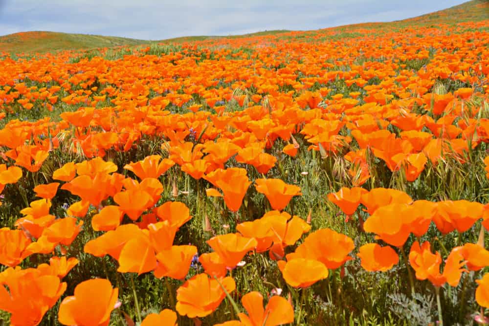
A seemingly never-ending field full of poppies isn’t just a location in “The Wizard of Oz.” There are numerous poppy fields that can be found throughout the world, including the Antelope Valley California Poppy Reserve in Lancaster. Each year, the state reserve is typically filled with blooming flowers from mid-February through May.
The rows and rows of flowers may look as if they were arranged by a large team of florists, but they actually grow naturally. To keep the reserve as natural as possible, California State Parks does not water or stimulate the flowers in any way. Every flower in the reserve is protected as well, so picking a poppy is not allowed. Group tours of the reserve can be arranged in advance by email.
10. Mobius Arch
Address: Movie Flat Road, Lone Pine
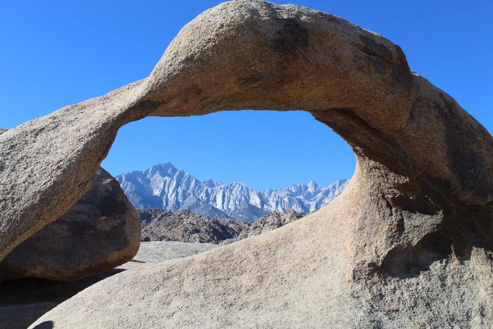
The Mobius Arch is so scenic, it almost looks as if it can’t be real. A naturally formed arch, the Mobius Arch is located in the Alabama Hills range. The arch is part of the Alabama Hills National Scenic Area, and can be accessed by hiking along the Mobius Arch Loop Trail, a 0.6-mile loop trail that takes visitors out to the arch and back.
One of the coolest things about the arch isn’t just the view of it, but the view through it. The Mobius Arch has a window more than six feet tall, which offers a stunning view of Mount Whitney, the highest point in the contiguous United States, when viewed through it.
11. Eureka Dunes
Address: P.O. Box 579, Death Valley
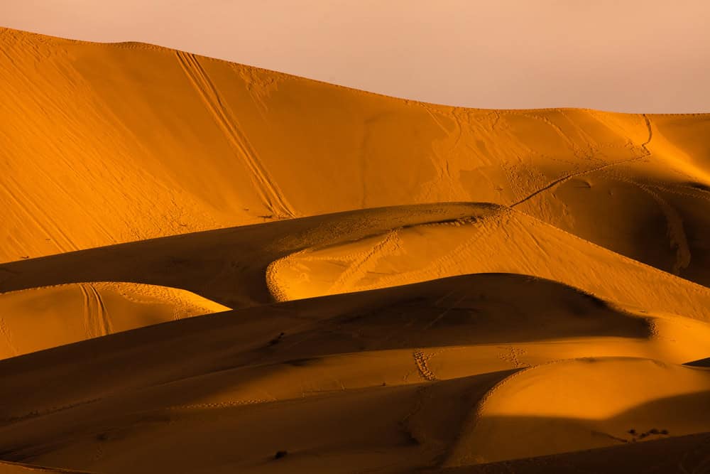
Normally, if you hear singing in a national park, it’s going to be a human, or possibly a bird. But at Eureka Dunes, in Death Valley National Park, it’s the sand. The dunes are one of the places in the world where visitors can hear singing sand, which produces a noise that sounds like a bass note on a pipe organ. The sound occurs when certain conditions are met: the sand must be round and between 0.1 and 0.5 millimeters in diameter, contain silica, and be at a certain humidity.
Those conditions are all met at Eureka Dunes, the tallest sand dunes in California, which rise more than 680 feet. The Eureka Dunes are part of Death Valley National Park, the largest national park in the contiguous United States, the site of the world’s highest recorded temperature, and the lowest elevation in North America.