From historic rock formations to towering mountains and cascading waterfalls, Michigan’s geological history can be found everywhere—if you know where to look.
You’ve definitely heard a list of the “Wonders of the World.” Meet the natural wonders of Michigan.
When you’re in Michigan, you’re at no shortage of natural wonders. Aside from the Great Lakes, of which Michigan touches four out of five, Michigan is known for its natural diversity in landscapes and ecosystems, especially when it comes to growing food. This diversity also expands to our natural features. While some are famous and others less known, our natural wonders captivate visitors year after year and contribute greatly to the tourism industry.
The world may have wonders like the Grand Canyon, Niagara Falls, Mount Everest, and the polar ice caps, but Michigan has its own version of these things. Want to know what we’d consider Michigan’s natural wonders? We’ve got a few suggestions.
Multiple Locations
Aurora Borealis
While one might think they’d have to travel to the arctic circle to see the Northern Lights, the Aurora Borealis is visible as far south as Michigan. And with so many dark skies in the Mitten State, there’s plenty of opportunity to gaze upon the beautiful, captivating ribbons of colored light.
The Aurora Borealis is most often visible from the Upper Peninsula, but depending on conditions, it can also usually be seen from the northern portions of the Lower Peninsula as well. In terms of latitude, northern Michigan is in an ideal spot; since the auroral oval dips further south on nights of stronger auroral activity, northern Michigan allows glimpses of this gorgeous weather phenomenon.
Dark skies provide the more optimal conditions to observe the Aurora Borealis. Michigan has a total of three internationally designated Dark Sky Parks: Dr. T.K. Lawless Park in southwestern Michigan (Cass County), Headlands Dark Sky Park Up North (Emmet County), and Keweenaw Dark Sky Park in the Upper Peninsula (Keweenaw County). Additionally, Beaver Island in Lake Michigan near Charlevoix contains the Beaver Island State Wildlife Research Area International Dark Sky Sanctuary. Six of Michigan’s State Parks also have designated dark sky preserves. These include Lake Hudson Recreation Area in southern Michigan (Lenawee County), Port Crescent State Park in the Thumb Region (Huron County), Negwegon State Park (Alcona County), Rockport Recreation Area (Presque Isle County), and Thompson’s Harbor State Park (Presque Isle County) in northeast Michigan, and Wilderness State Park in northern Michigan (Emmet County).
Michigan’s official website had additional tips for catching the Northern Lights in the Mitten State.

Michigan Rivers
With 656 miles of rivers, Michigan ranks fifth in the country for miles of rivers. Michigan’s 120 major rivers and many smaller rivers are part of the reason why you’re never more than 6 miles away from a body of water while you’re in Michigan. The majority of Michigan’s major rivers (40 percent) flow into Lake Superior, while a comparable amount (35 percent) flow into Lake Michigan. Lake Huron and Lake Erie take the remainder (25 percent).
For centuries, Michigan’s rivers have held vast importance to the Indigenous population as a means of transportation and a provider of food. The majority of Indigenous settlements in Michigan were found along waterways. This explains why most Indigenous burial and ceremonial mounds are found near water, such as those in Grand Rapids’s Ah-Nab-Awen Park. The 252-mile Grand River, which cuts through Ah-Nab-Awen, is Michigan’s longest river. The city of Grand Rapids was named for the Grand River’s now-submerged mile-long, 300-yard-wide, and 10-to-15-foot tall rapids.
Indigenous settlements were also plentiful along the 206-mile St. Joseph River, which originates in Hillsdale. Groups that inhabited this area include the Miami tribe and, later, the Potawatomi of the Anishinaabe (Council of Three Fires). Both the St. Joseph River and the Grand River connect to Lake Michigan. Other important tributaries of Lake Michigan include the 216-mile Muskegon River and the 130-mile Kalamazoo River.
Michigan’s largest rivers are not only noteworthy for their natural beauty, but also particularly popular for water recreation. Michiganders enjoy activities such as kayaking, canoeing, boating, paddleboarding, tubing, and fishing. Other major rivers in Michigan include the 190-mile Manistee River and 138-mile Au Sable River, both up north, and the 116-mile Menominee River in the Upper Peninsula. The southern side of the Lower Peninsula offers the 139-mile River Raisin, the 130-mile Huron River, and the 120-mile Shiawassee River.

Great Lakes Sand Dunes
Sand dunes are one of Michigan’s most well-known natural attractions. And that’s no fluke. Michigan features the most freshwater dunes in the world, with over 300,000 of our acres dedicated to these mountainous sand beauties. Though Michigan is not the only state with towering sand dunes, the ones along Michigan’s Lake Michigan shoreline are some of the best-known and most studied.
Near some of our beaches, particularly the Sleeping Bear Dunes National Lakeshore, massive sand dunes as high as 400 or 500 feet offer breathtaking views of the Great Lakes and warm sands that are worth a dune climb. Aimilar sand dunes accompany much of the Lake Michigan shoreline, and even spots along Lakes Superior and Huron as well.
Why so many sand dunes in western Michigan? They date back to when the Great Lakes themselves were being formed, around 1.8 million years ago during the Pleistocene Epoch. During this time, the entire area was affected by glacial drift, as massive sheets of ice moved across North America and changed the landscape. Aside from carving out the large basins for our Great Lakes, the glacial drift also transported and deposited sand and other minerals and sediments. These deposited materials were then repeatedly eroded, transported, sorted, and redeposited by the waters of a river or beach surf. This process is also what causes the sand of Michigan’s dunes to be rather uniform in size—smaller grains of sand are carried further by wind or water, while larger grains don’t move much at all.
As discovered more recently, the sand dunes are not simply old structures, but instead, constantly changing. Wind and water activity continue to shape, build, and erode the dunes. The same natural elements that reduce Michigan’s shoreline each year, in addition to human development, can all affect the size and shape of our dunes. In fact, this is one reason we don’t see the same types of dunes on the other side of Lake Michigan in Illinois—early Indigenous people settled in the lakeside areas that didn’t get as much lake effect weather, and the colonization and industrialization of the area made Illinois’s coastline one of the most intensely engineered coastlines in the Great Lakes.
Michigan continues to make efforts each year to slow the erosion of our shorelines and dunes, which preserves impressive heights for visitors to enjoy. The tallest dune in the state of Michigan is the main dune at Empire Bluff in the Sleeping Bear Dunes, with an impressive height of 526 feet. Another popular tall dune in the Sleeping Bear Dunes is Pierce Stocking, an incredibly popular dune of 450 feet in height. Other popular sand dune hotspots are the Silver Lake Sand Dunes, where visitors frequently drive dune buggies. Warren Dunes State Park is a popular choice for those in the southwest part of the state, standing out as Michigan’s most-visited state park. Saugatuck Dunes State Park has a hidden ghost town, Singapore, a nineteenth-century lumbering and shipbuilding town that has since been reclaimed by the sands, which has led to its nickname as “Michigan’s Pompeii.” The Grand Sable Dunes are a dune feature along Lake Superior, within the Pictured Rocks National Lakeshore.

Eastern Upper Peninsula
Sandstone Cliffs at Pictured Rocks
Alger County
Though this lakeshore can be found in a remote part of the Upper Peninsula, it’s well worth the trip. The Pictured Rocks National Lakeshore is not only America’s first National Lakeshore but also one of Michigan’s most gorgeous photo-op locations year after year, winning not once but twice in the National Park Service’s #ShareTheExperience Photo Contest, which included photos taken across the country.
The eponymous “Pictured Rocks” are actually sandstone cliffs that rise anywhere from 50 feet to 200 feet above the surface of Lake Superior. The photo-worthy cliffside stretches for about 15 miles, from Sand Point in the west to around Spray Falls in the east. The cliffs are best viewed from the water, and even though Pictured Rocks is a popular kayaking spot, the waters of Lake Superior can be challenging and treacherous. Fortunately, they are also viewable from convenient cruises.
The trademark colorful streaks in the sandstone are the result of centuries of geological processes. The sandstone is actually three layers representing different time periods, with the earliest layer dating back to the Midcontinent Rift System (MRS) 1.1 billion years ago. The mottled red Jacobsville Formation (Precambrian) is the oldest rock both below and just above the water’s surface. Stone from this geological layer, called Jacobsville Sandstone, was particularly popular for construction; buildings made from this sandstone can be found throughout the Upper Peninsula. On top of the Jacobsville layer is the white and gray Munising Formation (Cambrian). Finally, the youngest layer of the Au Train Formation (Ordovician) forms a harder and more resistant layer than the others, which is optimal for the development of waterfalls.
The colorful streaks along the cliffside developed from groundwater seeping out of the rock, dropping along the cliffside, and evaporating. Each color on the cliffside was created from a different mineral, like iron (red and orange), limonite (yellow-brown and white), copper (blue and green), and manganese (brown and black).
The Pictured Rocks also have a few other older rock formations. Miners Castle is the only cliff area accessible by vehicle. The rock formerly had a unique formation of two “turrets” that made it look like a castle, but one of the turrets unexpectedly fell into the lake after a rockfall in 2006. Chapel Rock, once known as La Chappelle, is another geological feature in the park, made from Cambrian age sandstone from around 500 million years ago and eroded by water activity since. It formerly had an archway connecting the rock to the mainland, but this arch collapsed in the 1940s. A lone white pine tree has made its home on Chapel Rock for an estimated 250 years.
Fun fact: the Chapel Rock Sandstone and Miners Castle Sandstone are composed of completely different sediment layers. Respectively, Chapel Rock Sandstone originated from the highlands to the south, while Miners Castle Sandstone came later, from the east. This is why the two structures look entirely different despite their proximity.

Lakeside Caves at Alger Underwater Preserve and Pictured Rocks
Alger County
With an estimated 1.500 shipwrecks sitting in Michigan’s waters, Michigan has plenty of opportunities to see a sunken ship. But on Lake Superior from just west of Munising and through the Pictured Rocks National Lakeshore to Au Sable Point is one of Michigan’s best opportunities for snorkeling and underwater photography.
The Alger Underwater Preserve was first established in 1988 by the Department of Natural Resources, the first preserve established in Michigan. The underwater visibility in the preserve is considered among the best in the Midwest, with about thirty feet of visibility at a depth of 100 feet. And there are plenty of things to see underwater.
Among the shipwrecks in the Alger Underwater Preserve are a wood-hulled freighter, a 260-foot three-masted steamer, a 235-foot wooden steamer, and a 150-foot wooden schooner.
One of the biggest natural attractions is the underwater caves, often called “sea caves,” even though Lake Superior isn’t a sea. Vigorous wave action from Lake Superior over the course of thousands of years has carved a plentiful amount of caves into the underwater sandstone cliffs. Snorkelers and divers can see these caves at a water level as shallow as 10 feet below the surface. An underwater camera is recommended to capture the underwater sights.
Black Rocks in Presque Isle Park
Marquette County
If all your friends jumped off a cliff, would you do it too? That’s exactly what often happens to the Northern Michigan University college students when they visit the infamous Black Rocks. And, yes, they often do jump.
The Black Rocks can be found in Presque Isle Park, immediately north of Marquette’s famous Upper Ore Dock (built in 1912). Presque Isle means “almost an island,” because the Presque Isle Park area is its own 323-acre peninsula. As little as 5,000 years ago, when Lake Superior’s water level was about 25 feet higher, Presque Isle actually was an island. When the lake lowered, an underwater ridge of sand known as a “tombolo” connected Presque Isle to the mainland. The tombolo still provides the road access today.
The Black Rocks are an ancient basalt formation rising above 20 to 30 feet over Lake Superior and have stood the test of time for 1.7 billion years. The Black Rocks are actually a metamorphosed igneous peridotite, pushed up by what geologists suspect was a mantle plume. The Black Rocks layer lies beneath the Jacobsville Sandstone that normally sits at the water level in Lake Superior, proof that geological activity over a billion years ago caused this layer to rise in this particular location.
The Black Rocks are often popular as a cliff-diving spot in the summer. Marquette officials discourage jumping due to how unpredictable and hazardous Lake Superior often is. However, if you do decide to jump off a cliff, it really is better if all your friends are doing it since you’ll be in a group, and don’t dive headfirst or at night.
Nearby the Black Rocks, along the west side of Presque Isle Park, is Sunset Point. Sunset Point is one of the best spots in all of Michigan to watch the sunset.
Kitch-iti-kipi
Schoolcraft County
Just twelve miles outside of Manistique is Palms Book State Park, which contains Michigan’s largest freshwater spring. Kitch-iti-kipi, meaning “big cold spring” in the indigenous Ojibwe language, is 300 by 175 feet in size, and 42 feet deep. The picturesque crystal-clear waters have led to the spring also being called the “Mirror of Heaven.”
Kitch-iti-kipi is particularly noteworthy because its brilliant blue waters retain a consistent temperature of 45 degrees Fahrenheit, even in the cold Upper Peninsula winters. Kitch-iti-kipi’s lakebed is made of limestone with many fissures, and in these fissures, more than 10,000 gallons of water gush through the cracks every minute. This temperature also perfectly preserves the fallen trees in the spring. The spring has only frozen twice in Michigan’s history—once in April 1934, and once again in March 2021, for reasons that aren’t quite clear.
Over 100,000 visitors every year observe Kitch-iti-kipi’s beauty via a self-operated observation raft with a viewing window. Through the window, viewers can easily see the aquatic life and network of old tree trunks and limbs below.

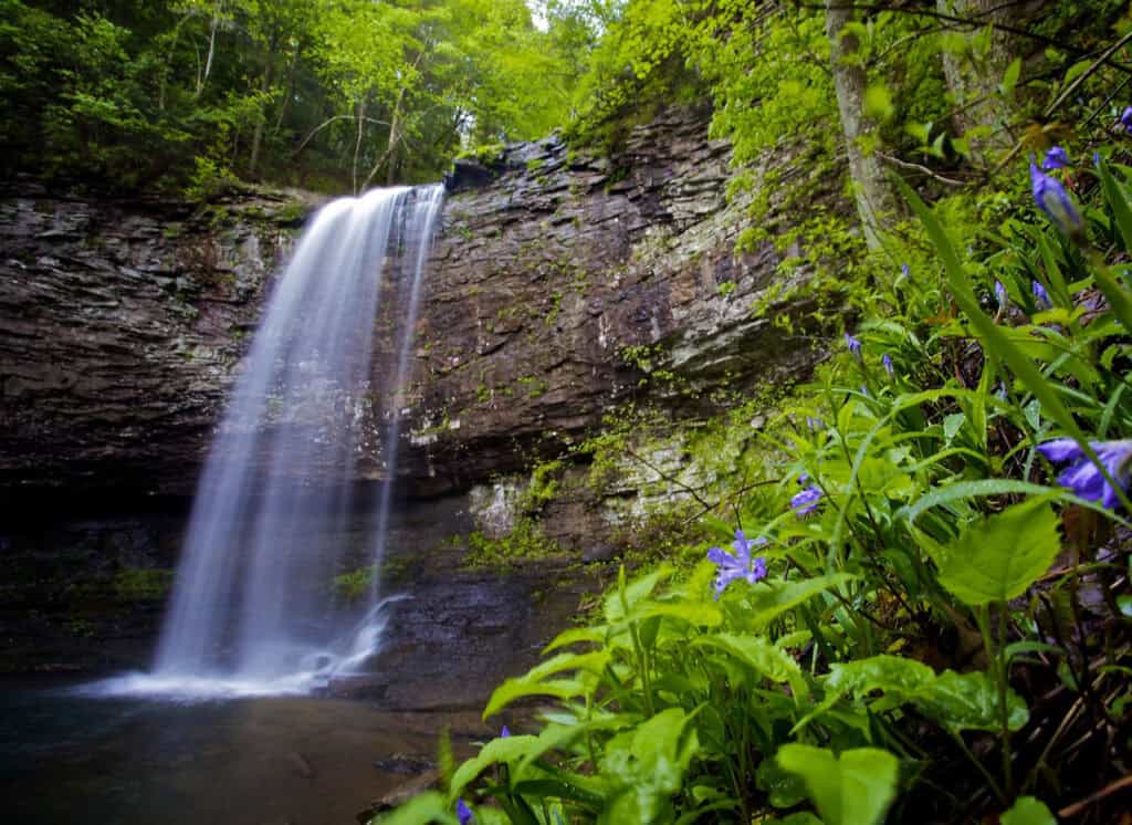
Cola Falls of the Tahquemenon Falls
Chippewa County
For decades, the Tahquamenon Falls (pronounced Tuh-KWAHM-in-uhn) have been a popular vacation spot for many Michigan families. This well-known state park has not just one, but two sets of waterfalls. The Tahquamenon Falls are often called the “Cola Falls” or the “Root Beer Falls.” The “Cola” of the Cola Falls comes from the high level of tannic acid in the water. The cedar, spruce, and hemlock trees and swamps along the Tahquamenon River cause the natural leaching of tannins into the water, which ends up coloring the falls.
The Upper Tahquamenon Falls are the larger and more famous of the two waterfalls. With a width of 200 feet accompanying a 50-foot drop, the Upper Falls are the most voluminous waterfall east of the Mississippi River. In fact, their size is comparable to Niagara Falls. The Upper Falls even have the Tahquamenon Falls Brewery and Pub on the waterfall to offer a bite to eat or a pint of beer to any wayward park-goer.
Four miles downstream are the Lower Tahquamenon Falls, a collection of five smaller waterfalls surrounding an island. The Lower Falls are often considered a natural outdoor waterpark, with a gentle current that creates an all-ages swimming hole.

Eben Ice Caves
Alger County
Michigan has plenty of year-round natural features, but the Eben Ice Caves are one that you can only see in the winter.
Located in Rock River Canyon Wilderness Area, which is part of the Hiawatha National Forest, the Eben Ice Caves are not truly caves. The ice caves are formed from water seeping through the Rock River Gorge and dropping off small cliffs. When the air creates a cycle of ice melting and water refreezing, it creates impressive columns of ice. These ice columns create otherworldly tunnels and gorgeous environs that are fun to explore at any age.
Because this is a seasonal weather phenomenon, the Eben Ice Caves are subject to weather conditions and change every year. Additionally, ice climbing is popular in the area, so ice climbers can easily alter the icy landscape.
To get to the caves, you must make a moderately challenging hike through the 4,700-acre Rock River Canyon Wilderness Area. In the middle of winter, this means trekking over ice and snow, so if you go, bring your ice cleats.
Sugarloaf Mountain
Marquette County
Michiganders don’t have to go all the way to the Rockies or Appalachia to climb a mountain. In fact, Sugarloaf Mountain is so accessible that you can complete a leisurely climb in under an hour, without having to stray far from civilization.
Located on County Road 550 about six miles north of downtown Marquette, Sugarloaf Mountain is a 470-foot Laurentian granite mountain that offers some of the most gorgeous views of the Upper Peninsula in multiple directions. In 1821, historical figure and United States Indian agent Henry Rowe Schoolcraft first recorded the mountain’s name as Mount Totosh, which was what the indigenous population had named it. Schoolcraft desired to name it Schoolcraft Mountain after himself instead. However, the name never quite caught on, and in 1846, it was listed as Mount Burt in honor of government survey party leader William Austin Burt. It’s unknown how, but at some point during the latter half of the nineteenth century, the mountain gained the name Sugarloaf Mountain, a reference to how sugar was sold in loaves during that time period, and the name stuck.
The trail up the mountain has plenty of century-old trees and ancient rock outcroppings, preserving the Upper Peninsula’s geological history. The trail loop has an “easy” direction and a “difficult” direction, depending on the physical challenge sought by the visitor, but due to the elevation, both pathways are a little challenging. At the summit, three viewing platforms offer picturesque views in whatever direction strikes your fancy: south, north, and west. The southward deck offers gorgeous views of downtown Marquette, the Upper Ore Dock, and Presque Isle. The northward deck is perfect for gazing at Lake Superior and Little Presque Isle island. And the westward deck is great for watching the sunset over Hogsback Mountain.
Also at the summit is a twelve-foot-tall monument. This obelisk was erected in 1921 by Marquette’s Boy Scout Troop One. The monument was built in honor of their Boy Scout Troop Leader, Alanson Barlett “Bart” King, who had died in World War One and had loved Sugarloaf Mountain. Impressively, for four months in the fall, sometimes with up to twelve trips per day, the troop hauled over a thousand smooth rocks, a hundred bags of cement, and three thousand pounds of lumber up the side of the mountain. Even King’s mother could see the monument from her house in Marquette.

Ancient Cedars at Fayette Historic State Park
Delta County
Michigan’s forests certainly offer a timeless beauty, but it might surprise you to know that Michigan also has some of the oldest trees in North America. Fayette Historic State Park preserves a Michigan ghost town originally dedicated to smelting pig iron. However, the park also preserves Michigan’s oldest trees.
Within the 711-acre park, you can see white dolomite limestone cliffs. Atop these cliffs are white cedar trees estimated to be as old as 1,400 years. The trees themselves are actually ironically small, making this a blink-and-you’ll-miss-it attraction. White cedars are known as some of the slowest-growing trees to exist. However, despite the lack of drama around these trees, they are older than the entire history of Fayette and have been standing longer than Europeans settled North America.
If you want to view these old trees, you’ll have to do so from a distance. The white dolomite limestone cliffs are closed off and can’t be accessed by the public very easily. The best way to admire the cedars’ age and beauty would be to do so from a distance, or from the water while in a boat or kayak.
Western Upper Peninsula
Lake of the Clouds in the Porcupine Mountains
Ontonagon County
Both Michiganders and tourists alike are often unaware that Michigan has its own mountain range. In fact, this mountain range is one of the oldest mountain chains in the world, having stood proudly for over two billion years. The Porcupine Mountains, also called “The Porkies,” are a severely underrated Michigan attraction. But for those in the know, the Porkies is one of the few remaining large wilderness areas in the Midwest, and definitely worth an adventure. The name was chosen by the indigenous Anishinaabe people because they recognized how the area’s silhouette resembled a crouching porcupine.
The Porcupine Mountains Wilderness State Park clocks in at a whopping 60,000 acres of old-growth forest and gorgeous waterfalls, more than enough acreage to earn its title as Michigan’s largest state park. The area is home to the most extensive old-growth northern hardwood forest in North America west of the Adirondack Mountains, with most of it the “maple-hemlock” type. The park was established in 1945 to help preserve this old-growth forest.
The Porkies have several gorgeous geological features, but by far the most remarkable is the Lake of the Clouds. The lake is the most photographed feature in the entire Porkies, and one of the top photography subjects in the Upper Peninsula. The Lake of the Clouds is a massive 133-acre inland lake, perfectly situated between two ridges of the Porcupine Mountains for optimal Instagrammable beauty. Surrounding the Lake is “virgin” wilderness, an aged forest that has remained untouched by human development. The lake is fed from the east by the Carp River and eventually empties into Lake Superior.
The scenic vista for the Lake of the Clouds is ADA-accessible. Though the lake is popular for bass fishing, it’s catch-and-release only and there are no boat rentals. You can get even better shots of the lake by taking either the Big Carp River Trail or the Escarpment Trail. But keep your eyes peeled for wildlife—you might just spot coyotes, predatory birds, bears, large cats, or even wolves on the trail.

“Singing Sands” of Bete Grise Beach
Keweenaw County
At more than 3,000 miles of shoreline, Michigan has the longest freshwater coastline in the world and more than 1,000 beaches. Yet, out of all those beaches, only one beach is unique enough to have sands that famously “sing.” And curiously, travelers report these sands will no longer sing away from the beach—they only sing on location.
Bete Grise (pronounced bay-de-gree) is a white sand beach in the Keweenaw Peninsula, 18 miles southwest of Copper Harbor. Its name means “gray beast” in French. This Lake Superior beach was originally known as Baie De Gres, which means “bay of sandstone.”
The origin of Bete Grise’s name is one of two legends about the area. The “gray beast” name comes from local Indigenous legends. The indigenous people harvested the blueberry bogs near the bay, and once they were done, would burn what was left. The burning bogs may have formed into a large smoke cloud that rolled over the bay and took the form of a huge beast. The stories of this “gray beast” are similar to the Michigan Dogman creature but without any confirmed sightings.
On the Bete Grise Beach, visitors can make the sands “sing” simply by hitting the surface of the sand, as well as brushing or swirling it. The sand makes noise similar to a dog’s bark or two balloons brushing against each other. Some Michiganders report a similar phenomenon at Warren Dunes, Ludington State Park, and Au Train Beach.
The other primary legend of Bete Grise purports that the beach has a mystical power that ceases to be if the sands are removed from the beach. Indigenous folklore tells a story of an indigenous woman whose lover drowned in Lake Superior. The woman was reportedly so heartbroken that she spent the rest of her life on the beach, calling out for him. The sands carry her voice to this day, and when beachgoers make the sand sing, they are allowing her voice to continue echoing beyond the grave, still calling out for her lost lover.
Though not fully understood, scientifically speaking, the sound is caused by an audible vibration of the grains of sand moving against each other, as sound is merely vibrations moving through the air. But only optimal conditions produce “singing” sands. First, the grains of sand must be relatively round and uniform in size. The sand must also have a certain silica content and be dry. Finally, the humidity must be very low.
Bete Grise isn’t the only beach with sand that makes noises, with the nearest being the Singing Sands Beach in the Bruce Peninsula National Park along Lake Huron in Ontario. Singing sand beaches exist on every continent except Antarctica, but they’re still rare at only about three dozen singing sand beaches in the world. However, in some cases, the activity at these beaches can be so massive that sand dunes may emit loud tones at noises as loud as a lawnmower or motorcycle and last for minutes. In some cases, the sands are audible even miles away.
Canyon Falls and Gorge
Baraga County
Everyone knows the Grand Canyon, but did you know that Michigan has its own Grand Canyon? And it’s one of Michigan’s best-kept remote, secluded secrets.
Within the Upper Peninsula’s Copper Country, a little over an hour away from Marquette, you can find the “Grand Canyon of Michigan” in the Canyon Falls along Sturgeon River. While the Canyon Falls are far from the tallest or the widest waterfalls in Michigan, it does have Michigan’s deepest valley. With the river carving through rugged rocky terrain for breathtaking cliffsides adorned with trees, you’ll think you’re somewhere in the Rockies, not the Midwest.
Canyon Falls can be found along US-41 about ten miles from L’Anse. There’s a trail leading to the falls from a roadside park, but it’s a pretty smooth 15-minute walk. While the trail ends right before reaching the Sturgeon River Gorge, many visitors wander into the wilderness to get the best photos of this natural wonder.
While cliff jumping is dangerous, the bottom of the second set of falls reportedly makes for a great swimming hole.
Greenstone Ridge on Isle Royale
Keweenaw County
Isle Royale is Michigan’s most underrated National Park, but it’s certainly not for the faint of heart. This remote island, which is only accessible via ferry ride or plane from Minnesota or Michigan, offers one of Michigan’s most venerated backpacking experiences. Isle Royale is prized for its abundant wildlife, such as moose and some of Michigan’s few remaining gray wolves. It’s also a living museum of Michigan’s geological history, providing history of the oldest, largest, and longest-lasting lava flow events on Earth.
About one billion years ago, long before melting glaciers created the Great Lakes, a great “failed” continental rift known as the Midcontinent Rift System (MRS) split the land of present-day North America. What followed was a rift valley that caused magma to ooze out from beneath the Earth’s surface. One particularly important layer of igneous rock folded as a result of tectonic plate movement, which led to the creation of Isle Royale along one upward curve and the Keweenaw Peninsula on the other upward curve, with the Lake Superior Basin in the middle. This same tectonic plate movement contributed to the abundance of copper in the Keweenaw Peninsula’s Copper Country, which contributed an estimated 1.5 billion pounds of copper to Michigan’s economy.
Geologically speaking, Isle Royale has been highly active since the rift. Isle Royale is made up primarily of ridges spanning from southwest to northeast. The centerpiece is the island’s topographic “spine,” a main ridge known as the Greenstone Ridge. The park’s primary 40-mile trail is named after this ridge. Greenstone Ridge is composed of altered basaltic rock rich in mineral layers, with the presence of minerals such as quartz, calcite, and copper providing evidence of the region’s past volcanic activity. The trail takes about three to five days to backpack in full, depending on the hiker’s experience.
Contrary to common belief, Greenstone Ridge is not actually composed of Isle Royale Greenstone, Michigan’s official state gemstone; the word “Greenstone” is a general term for multiple varieties of green-colored volcanic stone. The Isle Royale Greenstone is specifically chlorastrolite, a special and rare variety of pumpellyite. Though these distinct bluish-green stones with a “turtleback” pattern can still be located on Isle Royale’s beaches, you cannot legally take them home due to National Park System laws. If you want to legally get your hands on Michigan’s coveted state gemstone, you’ll have to travel to the Keweenaw Peninsula.
Douglass Houghton Falls on the Keweenaw Peninsula
Houghton County
Michigan has plenty of waterfalls, but there’s one set of falls that can claim to be Michigan’s tallest waterfall. The Douglass Houghton Falls in the Keweenaw Peninsula has a total height of 110 feet, and they’re located between the city of Calumet and Lake Linden, not far from McClain State Park.
Currently, the only way to access the falls is by taking a treacherous, difficult, and not entirely legal climb following Hammell Creek. Though the Douglass Houghton Falls are not part of Michigan’s park system just yet, there’s a good chance they’ll become Michigan’s newest State Park soon.
The Douglass Houghton Falls are located on 70 acres that formerly belonged to Vietnam Veteran James “Jim” Kuusisto and his family since 1949. The Douglass Houghton Falls was formerly a popular spot for Michigan Tech students, but much of the area had become unsafe due to the natural erosion of the cliffs. The falls were officially closed to public access in 1996 after multiple tragic deaths among hikers. Over the years, Kuusisto had several offers to sell the falls, but he resisted them all until approached by the Michigan Department of Natural Resources (DNR) in 2015.
Jim Kuusisto was still reluctant to sell the property but agreed to sell it to the DNR under the condition that the site be dedicated as a Veterans Memorial Park. Kuusisto and the DNR officially reached an agreement in 2018. Unfortunately, Kuusisto passed away in December 2021, before he could see his family’s land officially become a State Park.
Currently, the falls are on their way to becoming a new tourist attraction for the Calumet area. The Michigan House of Representatives passed a bill in April that would designate Houghton-Douglass Falls as a state park linked to McLain State Park. Republican State Rep. Greg Markkanen of Hancock sponsored the bill.
The DNR has yet to release an official timeline for reopening the falls. However, the DNR has reported several planned steps to ensure safety at the site before officially reopening the falls. In addition to a parking area accessible from M-26, they plan to install accessible features, including handrails and handicap features. Also in the plans are memorial signage for veterans. A ceremony is reportedly in the plans for a grand opening.

Mount Arvon in the Huron Mountains
Baraga County
If one were to ask an average Michigander where the tallest point in Michigan is, they might be tempted to answer with a well-known landmark, like the Sleeping Bear Dunes. But Michigan’s highest point is actually more than three times as tall as its tallest sand dunes. In the Huron Mountains in the Upper Peninsula, tucked away from most of Michigan’s most populated areas, Mount Arvon rises 1,979 feet (603 m) above sea level, claiming the highest natural point in the state of Michigan.
Believe it or not, the Huron Mountains where you can currently find the impressively tall Mount Arvon actually used to be much taller. The Huron Mountains are made of Precambrian rocks that have gone through significant periods of erosion. Around one billion years ago, millions of years before land plants appeared on Earth’s surface, rainfall stripped away sediments from the mountains and deposited them into the valley below, which helped form a part of what the Upper Peninsula identifies as the Jacobsville Sandstone layer, one of the older layers of rock.
Though no official weather records are maintained in the mountains, Mt. Arvon gets significant lake-effect snow from Lake Superior. Annual snowfall estimates exceed 200 inches across the entire range, outranking Upper Peninsula cities such as Ironwood (averaging 176 inches per year), Ishpeming (averaging 161 inches per year), and Marquette (averaging 128 inches per year). Some individual high points get even more snow than that, averaging over 250 inches, much higher than Michigan’s snowiest city of Houghton (averaging 202 inches per year).
Mount Arvon is quite remote, but visitors can still get to the top in their cars alone. Most of the road to the summit is drivable, though individual conditions may make the trail too muddy to traverse by car. Many visitors hike at least part of the way to the top. The best times to visit are between May and October. Travelers recommend abstaining from Google Maps and instead using AllTrails and physical maps from the L’Anse Visitors Center.

Northern and Northwest Michigan
The Valley of the Giants on South Manitou Island
Manitou County
The Sleeping Bear Dunes National Lakeshore is one of Michigan’s most popular attractions, with 70,000 acres of sandy dune landscapes, where dunes reach as high as 450 feet. Anishinaabe storytelling tradition has passed along a well-known story about a large dune representing a mother bear, and two other islands representing her cubs. The “cub” islands, North Manitou and South Manitou Islands, are easily overlooked, but impressive in their own right. Both islands are places of remote wilderness where nature has conquered any attempts to settle the two islands. And on one of those islands, you can find some ancient trees.
South Manitou Island, the smaller of the two islands, had a small village as recently as a hundred years ago. Burton’s Wharf was founded in the mid-nineteenth century, intending to produce cordwood for Great Lakes steamships. During Michigan’s logging era, Burton’s Wharf had the only natural deep-water harbor between Chicago and Buffalo. But after the end of Michigan’s logging industry around 1910, South Manitou became more devoted to family farming. Most of the houses on the island were built between 1908 and 1920. In 1918, Michigan State University (then Michigan Agricultural College) chose South Manitou as a grow site for Rosen rye seed, which required a remote location and the light, sandy soils often found in northern Michigan. However, the South Manitou farming industry also dried up due to expense, and South Manitou is now nothing more than the ghosts of former buildings, like the remains of the old general store that can still be found along old Dock Road.
However, the fact that civilization has barely touched South Manitou Island means much of its natural landscape was preserved. The most significant part of this natural landscape is old cedar trees. By hiking a 6.9-mile trail and going just beyond the turn-off to the Francisco Morazan shipwreck, visitors can easily visit the Valley of the Giants on the southwest corner of the island. Here, some of the oldest and largest northern white cedars, more than three centuries old, stand as tall as 100 feet tall, including a former national champion. One fallen cedar has 528 rings, meaning it existed even before Columbus landed in America. The ancient grove is one of the rarest ecosystems in the country.
It’s something of a mystery why the Valley of the Giants survived to the modern day, but some speculate that since the bark is infused with wind-blown sand from the dunes, these trees would have been considered by early loggers too laborious to cut. Back then, loggers had to resharpen saws by hand, and sandy bark would have required them to continually resharpen.
The Manitou Islands are managed by the National Park Service. A ferry is available in the summer for day trips to South Manitou Island.
Arch Rock
Mackinac County
The famous island without cars, Mackinac Island, has plenty of timeless sights to see, such as the Grand Hotel and Fort Michilimackinac. But by far the oldest landmark on Mackinac Island is the ever-popular Arch Rock. And it’s one of the most photographed spots on the island.
A natural rock formation of more than 50 feet wide along the southeast corner of the island, this limestone arch was formed during the Nipissing post-glacial period when Lake Huron’s water level was high following the end of Wisconsin glaciation. The breccia rock formation is quite rare because it doesn’t occur often in the Great Lakes region, and limestone is not a good material for natural bridges. The impressive formation was made through thousands of years of wind erosion, water activity, and receding glaciers. The arch stands 146 feet above the Lake Huron shoreline, or 15 stories tall.
The indigenous people who once inhabited Mackinac Island held Arch Rock in great reverence. Their stories, especially those of the Ojibwe people, described the rock as a place of spiritual power. The most prevalent folklore story identifies Arch Rock as a bridge or a portal to the world of the afterlife, where departed souls could find their final resting place. Another story describes a “Master of Life” enraged by the actions of an Ottawa chief, so he sent a red sun to burn a hole in the rock, thus forming the arch.
Visitors to Mackinac Island can visit Arch Rock either by climbing 207 steps from Lakeshore Drive or by taking the trail from the inland. Other natural formations on the island from limestone breccia include Sugar Loaf, Robinson’s Folly, Chimney Rock, Scott’s Cave, and Lovers Leap.

Torch Lake
Antrim County
About 17 miles northeast of Traverse City is the second-largest inland lake by surface area in Michigan and the largest inland lake in regards to total water volume. Torch Lake is known for its gorgeous turquoise waters, which Forbes compared to the Caribbean. Several Michigan celebrities have had homes on Torch Lake, including Eminem, Michael Moore, and Kid Rock, who alluded to Torch Lake in his 2007 song “All Summer Long.”
Even though Torch Lake is known for its party atmosphere in the summer, the shoreline doesn’t have much beach to speak of. The majority of the beach-going activity happens at Torch Lake’s sand bar, located near the southern end of Torch Lake. The sand bar is a popular place for those with personal watercraft to park their boats and wade through the water. There are a few swimming beaches near the sandbar as well. There’s even a floating food truck called Torch Lake Tiki, which also allows visitors to rent kayaks, paddle boards, and floating platforms.
The reason for Torch Lake’s beauty has to do with the ice age glacial activity that created the Great Lakes. Torch Lake was formerly a fjord-like bay off the larger lake, Lake Michigan. As the glaciers retreated, a sand bar formed on what is now the lake’s northwest end, cutting the bay into a lake.
The crystal-clear turquoise waters actually have a geological basis. In the lakebed where the glaciers once sat is calcium carbonate, also known as limestone, flattened and ground to the bottom of the lakebed. The white sediment of the fine calcium carbonate, as well as its low organic content, helps make the water extra-clear. The waters of the Caribbean similarly have low organic content limestone beds.
As for the name, “Torch Lake” comes from indigenous fishing practices. When the indigenous tribes harvested fish with spears and nets, they used torches to attract fish at night. The European colonists called it “Torch Light Lake” before shortening it to Torch Lake.
The Michigan Champion Sequoia in Lake Bluff Bird Sanctuary
Manistee County
Michigan is probably the last place you’d expect to see a giant sequoia tree, which usually only grows between 4,000 and 8,000 feet of elevation on the western slopes of California’s Sierra Nevada mountain range. But along Lake Michigan, you can find a few of these legendary trees, known to be one of the most massive organisms on earth. Among this sequoia range is the largest giant sequoia east of the Rocky Mountains. And the fact that these trees are not struggling, but thriving in Michigan, offers some clues for what the future might hold for climate change.
Truth be told, the sequoias are not 100% natural; that is, they were planted outside their natural habitat by humans. In 1948, Edward Gray, the stepson of Morton Salt’s founder, together with his wife Gertrude retrieved six sequoia saplings from California to bring to Michigan. The eight-inch saplings were planted in the present-day Lake Bluff Farms property in Manistee County. Although sequoias rarely fare well outside the California climate, the saplings ended up thriving due to the Lake Michigan shoreline creating a balmy microclimate. If the saplings had been planted even 15 miles more inland, the climate would have been too cold to support the sequoias’ growth.
The largest of the original saplings, the Michigan Champion, is a striking 116 feet tall. Surprisingly, the tree is supposedly even healthier than the typical sequoias in California. Plus, sequoia trees could be monumental in slowing climate change. The giant sequoia sequesters carbon dioxide ten times faster than any other tree, meaning these gentle giants could be game-changers for reducing excess carbon in the air.
Though Michigan’s sequoias have only been around a few decades at most, this tree species can live to be up to 3,000 years old. And that’s a legacy you can expect to start seeing within the next few years. Communities such as Detroit are planning to plant their first-ever giant sequoia trees to help combat pollution and other carbon activities.
Northeast and Eastern Michigan
Hartwick Pines Old Growth Forest
Crawford County
Nestled in the wilds near Grayling lies a 49-acre sanctuary for white and red pine trees, a living museum and testament to Michigan’s White Pine Logging Era past. From around 1840 to 1910, Michigan’s forests were cut down en masse to be used as lumber for a developing nation. For about the last 30 years of the nineteenth century, Michigan was the nation’s leading lumber producer—at least, until most of the trees had been cut down.
The Michigan white pine forests that existed before the logging industry are mostly a thing of the past. But thanks to Karen Michelson Hartwick, a daughter and wife of lumber barons, all of Michigan has a little piece of the bygone pre-logging era trees. Ironically, Hartwick had these old trees on an 8,000-acre parcel of land because the virgin pine trees had been declared unprofitable by the lumber company.
In 1927, Karen Michelson Hartwick donated her land to become part of the present-day Hartwick Pines State Park. In exchange, the State of Michigan agreed to her requests: protect the forests, construct a road, establish a building dedicated in memorial to her husband, and honor her family’s legacy by building a museum about Michigan’s logging history.
Within the “old-grown forest” of the pine sanctuary, trees stand as tall as 160 feet tall and may be as many as 400 years old, as some trees pre-date the entire logging industry. Though a windstorm in 1940 eliminated some of the trees and acreage, enough forest still stands today that visitors can experience the serenity and quiet of what Michigan’s forests were like in the ages before colonization. Also available for exploration is the Hartwick Pines Logging Museum.
Ocqueoc Falls
Presque Isle County
Michigan may have several waterfalls big and small, but most of them are in the Upper Peninsula. The largest and only named waterfall in the Lower Peninsula is the Ocqueoc Falls, which is also the only universally accessible waterfall in the nation. These remote falls in northern Michigan allow visitors to access the falls via a decked ramp.
The falls are fed by the Ocqueoc River, which carve their way through the Mackinaw State Forest and towards Lake Huron. The falls have a total height of five feet and they spread the entire width of the Ocqueoc River. The water beneath the falls is particularly shallow, making the bottom of the Ocqueoc Falls a particularly popular swimming hole. Visitors report only a five-foot depth at most, with relatively smooth rocks at the bottom.
The rock layers of the falls are particularly interesting to examine. The falls are composed of layers of dolomite, limestone, and shale, with harder layers on top and softer layers further down. You can actually see fossils within the limestone, a more common feature in the Alpena and Presque Isle areas, because the area was formerly a shallow water reef in the Devonian Sea, ancient waters that existed in present-day Michigan 350 million years ago.
Six miles of trails running downstream from the falls, known as the Ocqueoc Falls Bicentennial Pathway. There’s also an adjacent camping area, managed by Hoeft State Park.

Rockport State Recreation Area
Alpena and Presque Isle Counties
This State Park just so happened to be Michigan’s hundredth, and also, one of its most unique parks. Not only is the Rockport State Park Recreation Area located on the gorgeous shores of Lake Huron with plenty of rugged trails, it also has a limestone quarry packed full of fossils, a preserve of virgin pine trees, an old pier from Michigan’s mining industry days, a ghost town, and an official Dark Sky Preserve to make for enjoyable evenings full of stars.
Back in the early 1900s, the Alpena region was used by stone and lime companies who mined the area for building and paving materials for our developing country. Within Rockport State Recreation Area, a 300-acre quarry stands as a testament to those forgotten days. From 1927 until 1958, Rockport was a major quarry that actually contributed to the pillars of the Mackinac Bridge. When the quarry was still operational, the excavators found plenty of rows and mounds of fossil-rich rock, unnecessary for the business’s operations. The quarry has since closed, but these rows and mounds still remain for visitors to take as many as 25 pounds of fossils per person per year. Fossils are so abundant that visitors are likely to trip on them.
Why so many fossils? During the Paleozoic Era, specifically the Devonian Period between 419.2 and 358.9 million years ago, Michigan was actually entirely underwater! Our pleasant peninsula was covered in shallow saltwater, with a subtropical biome significantly warmer than the cold winters we experience today. However, since the Michigan basin was underwater, that also explains why you’ll never find a dinosaur fossil in Michigan.
Fossils in Michigan, especially those in the Rockport area, are all marine life, such as shells and coral reefs. In fact, our famous Petoskey Stones are nothing more than fossilized Hexagonaria coral. At that time, there were no animals or humans existing in present-day Michigan. Most of the marine fossils are small-scale, due to the frequent occurrence of hurricanes which frequently killed life in the Devonian Period. The fact that the State Park allows visitors to collect the fossils is rare, which is evidence of both the fossils’ significance and abundance.
Also within the Rockport Recreation Area, towards the northern end, is the Besser Natural Area, which contains mature virgin white pine, the same tree species harvested during Michigan’s historic logging era, as well as red pine, balsam, cedar, and birch. The trail is easy and encouraged for children, especially since visitors can also explore the nearby ghost town of Bell, the town that formerly housed the Presque Isle Brick and Lumber Company. The town operated for less than 30 years, with the post office being established in 1884 and closing down in 1911. Some say the town is haunted; those who believe such stories may claim the spirits of the indigenous people and former Bell residents are trying to discourage visitors.
Sinkhole Pathway and Mystery Valley
Presque Isle County
When you think about sinkholes, you might tend to think about warmer states like Florida or Kentucky. But believe it or not, Michigan has its own sinkholes. And the thin layer between the surface and the underground world created by sinkholes is reminiscent of building video games like Minecraft.
Northern Michigan has what’s known in geology as a karst network, which refers to expressions left on or in rock by water action. Sinkholes resemble giant holes, but are actually more akin to collapsed caves. More than 200 sinkholes exist Up North in a layer of rock known as the Detroit River Group, but the majority of these sinkholes are located on private property. However, the sinkholes of Thunder Bay Karst Preserve and Shoepac Lake State Forest Campground are available for public access.
The most interesting aspect of sinkholes is the activity that happens below, in unexplored caves and caverns that are difficult to locate even with modern technology. When water accumulates, it can descend as far as 900 feet. But when a sinkhole forms, the thin layer of soil separating the surface from the lower caverns actually starts to break. Within the sinkholes, the combination of sulfur and salt with no natural light or oxygen creates environments for microorganisms known as cyanobacteria. These ecosystems are ultimately similar to what life on Earth looked like millions of years ago.
The Sinkhole Pathway is a two-mile trail loop that takes hikers around five different sinkholes, known as the Shoepac sinkholes. The trailhead is off Shoepac Lake Road. The nearby 52-acre Shoepac Lake is also a sinkhole, but one that is filled with water instead. The Shoepac Lake State Forest Campground is adjacent and offers rustic camping.
Not too far away from the Sinkhole Pathway is the 76-acre Mystery Valley Karst Preserve and Nature Sanctuary within the Thunder Bay Karst Preserve. The 1.5-mile-long Mystery Valley Sinkhole is one of the largest known collapse valleys in the Great Lakes Region, created through the collapse of the surface into subterranean chambers. The Earthcrack Trail and Valley Trail create two self-guided pathways to the preserve.
Turnip Rock
Huron County
If you know anyone who kayaks out in the Thumb Region, then they’re already aware of Turnip Rock. This privately owned natural rock formation isn’t publicly accessible by land and can only be visited through the water. But that hasn’t stopped paddlers from considering this rock formation an important milestone and achievement for the hobby.
Turnip Rock earned its name in a pretty obvious way; the rock itself has a bulkier top and a carved-out bottom, leading it to resemble a turnip. The rock is separated from the mainland, but it sits in shallow waters, making it easy for paddlers to access. It’s a limestone formation and a geological formation called a “stack” or “sea stack” among geologists. This is because wave action has not only separated the pillar-like formation from the mainland. In the case of Turnip Rock, further erosion has caused its turnip-like shape, with a narrow shape near the bottom accounting for wave activity severely undercutting the rock.
Since Turnip Rock is technically on private land owned by the Pointe Aux Barques Cottage Community, visitors can only see Turnip Rock by paddling several miles in a canoe or kayak, usually from Port Austin. It is also accessible via a chartered boat tour.